
Commentary by: Michael McWalter
Michael McWalter explains the important responsibility to care for the vast amount of petroleum data submitted to the Government by operating petroleum companies and for the need for the establishment of a National Petroleum Data Centre in Papua New Guinea to cater for the vast amount of information arising from petroleum operations.
The upstream petroleum industry is a recognised leader in the use of modern technology and has been ever since its foundation, always seeking new and innovative ways to locate the sites of new wildcat exploration wells which may probe the subterranean depths for hitherto undiscovered petroleum accumulations. This is no easy task as most of the easy to recognise prospects have been drilled already, and if they did contain commercial volumes of petroleum that could be extracted, they are by now largely exhausted and depleted of those reserves.
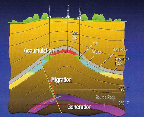
Modern day exploration does not simply seek to drill on dome-like hills to shallow targets next to surface oil seeps as was the modus operandi of Captain Drake at Spindletop in 1859 and his successors. Rather, the industry intelligently probes deep into the ground where the fundamentals of local geology are conducive to the generation of petroleum, its migration from a carbon-rich source and its accumulation in a porous reservoir within a confining geological structure out of which it cannot buoyantly spill to surface due to an impervious seal or cap rock. It is a high-tech data intensive business.
Seismic Data
This probing is most often done using the technique of reflection seismic surveys, much like the familiar echo-sounder used in a hospital image laboratory. Sound waves are directed into the subsurface in intensity and abundance and the many reflections of those sounds from changes in the properties of the rocks (typically, impedance, which is the product of the density of the rock and the velocity of sound in the rock) are equally recorded in abundance. These impedance contrasts often represent changes in rock strata – the beds of rock from sediments that have been thickly deposited in the Earth’s deep sedimentary basins. The technique is employed both on land and at sea. On land, a seismic line of sound sources and receivers are installed at regular intervals and shifted slowly forward after each shock; at sea, a boat trails a long streamer of receivers which are tugged behind it as a sound source is triggered at regular intervals in the voyage.
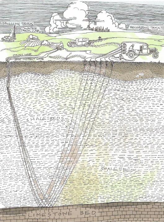
With multiple sound sources bouncing off multiple layers of rock to multiple receivers – geophones (essentially strong microphones), a plethora of data is collected. When suitably corrected for varying elevation, geometry, signal-to-noise ratios, correlated, and compiled, a representation of the geometry of the subterranean strata and their structural configuration can be shown. This is compiled in time-sections based on the two-way time for the sound waves to penetrate to and reflect from the depths. To gain more geological reality, these time-sections have to be converted into depth sections using the best estimates of the velocity of sound in each and every stratum penetrated. This is no mean feat and all manner of algorithms have been created to squeeze out the best seismic images that are the nearest to geological reality as possible. Added to this, seismic surveys may now be conducted not just with straight survey lines, but in 3-D arrays that provide a coherent tie of the data across the entire area of the survey; this necessarily multiplies the amount of data recorded and enables better seismic interpretation of the subsurface.
The seismic data of modern exploration is recorded and endlessly re-processed with ever more finesse of the geophysicist. Old data may be re-processed with modern techniques bringing out more features hitherto undiscerned from prior processing and interpretation. Old data is not simply obsolete, it is extremely valuable. It not only helps new surveys home in on geological leads and prospects, but provides the basic architecture and understanding of the petroleum basin in which one is exploring. Reprocessed seismic data may be added to new seismic data to save significant exploration costs. It thus has to be cared for and maintained in a readable format to enable the petroleum exploration of the future. Moreover, aside from being valuable to the petroleum industry, this vast volume of data about the subterranean geology has many other uses in modern society ranging from helping with earthquake awareness, building codes, land stability studies and more. If the data is lost, the only way to recoup it is to conduct the surveys afresh, which is unlikely without the commercial impetus to explore for oil and gas.
Other Surveys
Added, to seismic data is the data derived from other types of geophysical surveys. Years ago, intrepid geologists and explorers took with them delicate geophysical equipment to measure the strength of gravity and the strength of the Earth’s magnetic field as they traversed the land in geological surveys.
A major geological basin filled with less dense sedimentary rocks may reduce the local strength of gravity by about one ten thousandth of its normal value, whilst topographic effects may reduce the strength of gravity by a similar amount for every 400-500 metres of elevation (the gravity at the top of Mount Everest is about 0.2 % less than at sea level). These were very difficult measurements to make, but as with everything, technology has taken over and airborne gravity and even satellite gravity data is now available. So sensitive are these measurements that geophysicists usually work in units of a milliGal (0.001 Gal) where 1 Gal is an acceleration of 1 cm/sec2 as compared to the average force of gravity of 981 cm/sec2.
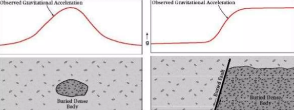
Magnetic surveys measure the variations in magnetic intensity. Because igneous basement rocks usually contain more magnetically susceptible iron-bearing minerals, when uplifted or nearer to the surface, they give positive magnetic anomalies which may suggest that the basement of a basin lies nearer to the surface, or indeed that a basin does not actually exist! Again, technology has taken over and aeromagnetic data acquisition is commonly used not only to determine the architecture of a potential sedimentary basin, but to reveal other structural features within it.
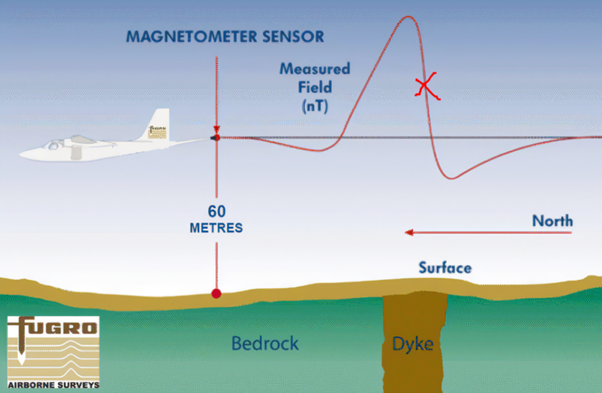
Both airborne gravity and magnetic data are nowadays routinely collected as they are cheaper than seismic data acquisition. They have evolved to the point where such work is integral in the early stages of basin exploration, frequently preceding and guiding the acquisition of seismic data. The speed and uniformity of coverage, plus the relatively low cost of airborne surveys, have consolidated their role.
Petroleum Geology
Of course, basic geological surveys have fundamental importance, but by their nature, they are only carried out onshore on landmasses where rock outcrops are assessed. That assessment is for the nature of the rocks, their relationship to one another, the structural configuration of the rocks (generally, their dip and orientation), and features of the rock: like fossils; minerals, bedding, jointing, fractures, and veins. This is basic geology which may or may not reveal the presence of a sedimentary basin and the important ingredients for the preservation of oil and gas accumulations. A petroleum geologist is always keen to find geological evidence of source, migration, reservoir, trap and seal, and his first call will be for a geological map of the area of interest for exploration to provide evidence of such pre-requisites for the accumulation of oil and gas.
Pre-requisites for a petroleum accumulation
- a source rock typically a dark shale with sufficient organic content that when buried and heated will generate petroleum
- evidence of the movement and migration of generated petroleum from source rocks through rock strata, that may then be caught in a reservoir, rather than be leaked to the surface
- reservoir rock that has not only sufficient porosity (space between its grains) to contain petroleum, but adequate connection between the pore spaces to permit that petroleum to flow
- a closure or trap made by a configuration of rock strata that either through folding, faulting or pinch-out define a structure within which petroleum may accumulate
- containment or seal of the structure by a barrier to the flow of petroleum, created by impermeable rocks and structures which prevent further upward buoyant movement of petroleum.
This process of elucidating the subsurface to determine prospects where there is a chance of finding petroleum accumulations involves the gathering of enormous amounts of data about our Earth. Such knowledge is only gained at great expense and is therefore valuable data that needs to be preserved for future petroleum industry use and general public use.
Drilling
With the massive extent of offshore exploration worldwide, the preponderance of petroleum exploration data these days is seismic data, but this is only the start. The hypotheses of the geologist and the geophysicist have to be tested by that most famous “rotary lie-detector” more properly called the drilling bit. Wells have to be drilled to physically identify whether there is indeed an accumulation deep in subterranean depths and whether there is a reservoir in a trapping structure with an impervious seal and whether that reservoir contains an accumulation is just water, or perhaps oil and/or gas generated and migrated into it.
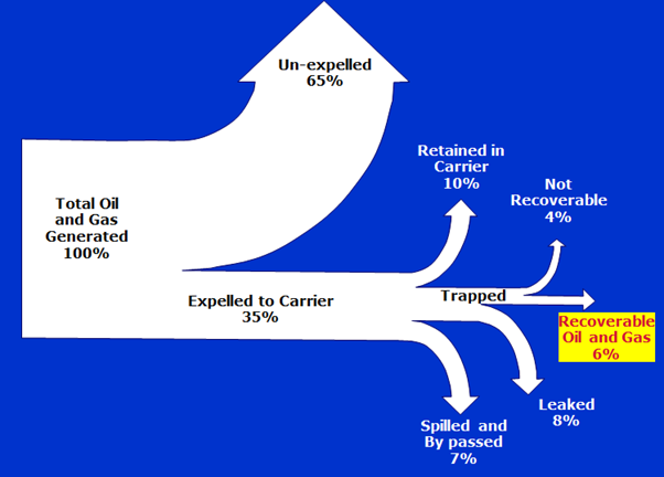
The process of drilling a wildcat petroleum exploration well is akin to making a movie. It is capitally intensive and budgets can get rapidly out of control. In reality, commercial wildcat exploration success rates worldwide range from 30% to 40%. This is achieved through very careful prospect definition based on screening the chance of all the necessary ingredients being present in a prospect in the right timing. We must recognise that recoverable oil and gas represents just 6% of the total hydrocarbon fluids generated. Some 65% remains un-expelled from the strata in which it was generated and is now the subject of intense exploitation in the continental USA – as shale gas and shale oil plays. Of the 35% that does get expelled, 10% is retained in the carrier, 8% is leaked naturally (as gas and oil seeps), 7% is spilled and bypassed, and 4% is not recoverable. But like movie hits amongst a litany of ordinary movies, there are a few blockbusters that can change the fate of a company and even nations on occasions. It is an industry which employs all skills to do as best it can.
The drilling of a well can cost many millions of US dollars. Whilst it may costs just US$ 2 to 4 million for a simple well onshore in the USA, mid-size companies like ENI and Equinor quote figures of US$ 5 million to US$ 10 per well, but some wells in Papua New Guinea and other remote frontier areas of the world cost of the order of US$ 100 million each.
With such large stakes, it is certainly expedient to manage the exploration data that leads up to the decision to drill most carefully and then to gather as much information as possible during the drilling process to make sure that no hydrocarbons are missed or overlooked, to optimise production in the case of success and to optimise future efforts based on the new knowledge gained.
Logs
The process of drilling reveals the nature of the subterranean sediments sequentially as the drilling bit works its way through the strata. Geologists sample and examine the cuttings of rock brought to the surface by the thick viscous drilling mud describing the penetrated rock and looking for signs of oil stain on the cuttings. The drilling mud as it emerges from the hole is whisked to release any entrained gases which are then analysed in a gas chromatograph to determine their type (typically, paraffins or alkanes ranging from methane to pentane). If any signs of oil or hydrocarbon gas are found they are called shows. Special gas detectors examine the drilling mud for noxious gases such as carbon dioxide and hydrogen sulphide, the latter of which is deadly poisonous. Aside from such step-by-step description of the rocks, potential hydrocarbons, and gaseous contaminants, other specific features of the rock may be examined such as density of any shales and the calcimetry of carbonates to distinguish limestone from dolomite. Added to this, many drilling parameters are measured to help optimise the progress of drilling and to identify zone of over pressure in the rock. Masses of data are thus collected and collated in well logs that describe the geology that the well penetrates.
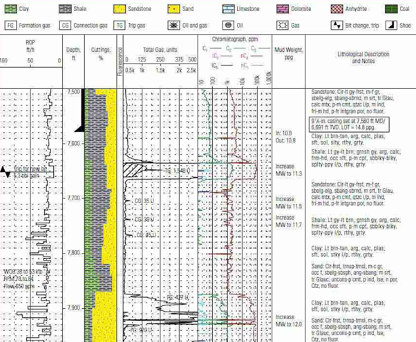
After a section of hole has been drilled, it is logged with special electrical tools that are lowered into the well bore on a strong electrical cable called a wireline. A detailed analytical record of the geology penetrated by a borehole is made recording the petrophysical properties of the strata using a variety of sensors. These measure the natural gamma ray, electrical, acoustic, stimulated radioactive responses, electromagnetic, nuclear magnetic resonance, pressure and other properties of the rocks and their contained fluids. The data itself is recorded and then printed as a well log showing the measured parameters by depth in the well.
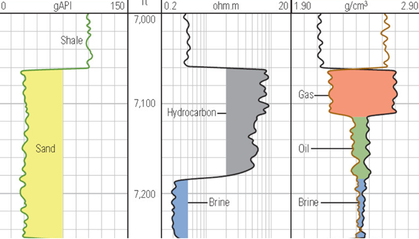
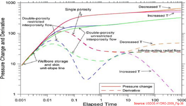
The logs of the geology and hydrocarbon shows of the well are analysed together with the physical parameters of the rocks as determined from the wireline logs to deduce the likelihood of there being moveable hydrocarbons within any porosity at the different levels of the well. If there are coherent signs of there being any reservoirs containing hydrocarbon, then well testing may be undertaken to test if these fluid will actually flow to the surface naturally. Again, as a well is tested vast amounts of data are recorded of the type of fluids produced, their quantity and quality, the surface and subsurface pressures during flow and whilst the well is closed, Such data will help in making estimates of the size, shape, and quality of the oil and/or gas reservoir, as well as optimise the future production and recovery strategies.
Whilst this sequence of exploration produces lots of interesting data for the exploration company contracted to or licensed by the host government State, it must be realised it is all collected with the aim of identifying as big an accumulation of oil and/or gas as possible from which commercial production may be undertaken. Whilst a proper academic understanding of the subsurface geology is necessary to optimise the finding of hydrocarbons, it is only a precursor to production and subsequent sale of the produced oil and gas for value. The international oil companies will not be so interested in the samples and data collected from well once the accumulation has been satisfactorily produced, other than to possibly revisit the field and its wells at some later date if economic circumstances make any remaining oil and gas left in the reservoir commercially viable to produce again. The samples and data will have value for future nearby prospecting as they will help elaborate the local and regional geology. However, oil companies wax and wane in their interest over a given area depending on the range of international opportunities that they have for investment. A large discovery in a faraway country may distract an emerging exploration programme that might be on the cusp of success at home. Priorities might be to produce what has been discovered rather than look for more accumulations. The steadfast entities behind all of this are the host government petroleum industry regulators who are only involved with the petroleum potential and outcome of exploration and production in their own jurisdiction.

Role of the Government Petroleum Regulator in Respect of Data
It is a fundamental role of the host government petroleum industry regulator to take care of the data. In all jurisdictions, the exploring companies must lodge copies of all the data that they acquire in the course of their endeavours with the host government petroleum industry regulators. After all the resources are owned by the people of the Nation and the knowledge that the petroleum exploration data reveals has been obtained at vast expense which would not be made were it not for the lure of potential petroleum accumulations and the possibility of their production at scale making extraordinary revenues for the companies and their host Government alike. Aside from the many task of the government petroleum regulator the care of historic and legacy petroleum data is vital. If all else fails in the administration and regulation of the petroleum industry and its exploration activities, the data acquired from such work must be collated, protected and cared for. It has lasting value to ongoing investment in the petroleum industry and to all other uses of geological data ranging from mineral exploration to geo-hazard awareness to road and other infrastructure development to building codes. The data is quite essentially part of the patrimony of the Nation.
PNG Petroleum Data
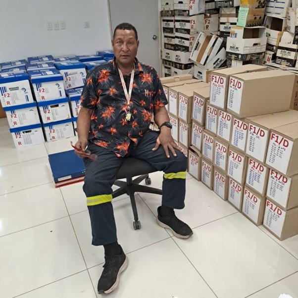
The PNG Government’s petroleum data is stored by the Petroleum Division of the Department of Petroleum’s archives and dates back to the early 1920s. The archive contains the results of all exploration endeavours for the discovery of oil and gas to date. As said, this information is the product of immense investment over time and has to be looked after. The Petroleum Division has indeed attempted to care for this data and has from time to time launched initiatives to improve its data storage and management, but it remains a daunting task notwithstanding the overture of various seismic companies and data specialist companies to help. Considering the enormous value of the petroleum resources that have been and continue to be extracted and exported, far too little attention has been paid to this aspect of the overall business. Given the physical extent of the current Petroleum Division archive, not enough financial and human resources are devoted to its maintenance, and there is an urgent need to bring the management of the PNG petroleum archive held at the Petroleum Division up to current standards. Bilateral, multilateral or even corporate funding could be solicited to help in this process as often occurs around the world.
To date, it is estimated that only around 350 wells have been drilled in the course of exploration work by the oil and gas companies. These wells were based on hundreds of geological field surveys, magnetic and gravity surveys (potential field surveys) and equally hundreds of seismic surveys both onshore and offshore. In 2006, it was estimated that the Petroleum Division Archives held at last 65,000 records. One would anticipate that this figure has now risen to around 75,000 records.
In recent years, digital submission in addition to hard copy submission has been encouraged by the Petroleum Division on CD ROMs and in the case of geophysical data on Exabyte or similar tapes. The immediate problem is straightforward and that is the housing of these records in a controlled environment safe from weather, pests and interference. The author’s own home library with some 4,000 books, papers, files and manuscripts occupies 68 metres of shelf space, so an archive consisting of 75,000 records implies a need of at least 1,275 shelf metres, just to accommodate the primary existing documentation and records. Tapes and other digital media also need constant attention to prevent data deterioration as much a printed paper media.
The Data Challenge
The ultimate challenge would be to transcribe the entirety of the Petroleum Division archive to permanent memory either to high volume hard disks which can now hold as much as 20 Tera Byte (TB) or to Solid State Drives (SSDs) that can now hold as much as 100 TB. The capacity of data storage devices seems to increase year by year. Fifteen year ago a disk drive that could hold 5TB seemed to be an impossible large. The new 100 TB SSDs are quoted at about US$ 40,000 each. Just ten of them would represent 1Peta Byte (PB) perhaps enough to hold the complete PNG Petroleum Division archive including all seismic and other geological and geophysical data plus all drilling and production data. The quantum of basic storage costs therefore seems to be about US$ 400,000.
That is not the only cost though as there also have to be systems that can support and operate these data storage devices and enable data to be deposited and retrieved. Back-up systems, data acquisition and preparation drives, scanners to prepare printed media documentation for digitalisation, network access, and maintenance and training all have to be considered. All of this has to be housed in a high integrity building free from ambient dangers with a highly-controlled environment secure from all threats, and its own systems of reliable power supply, and alas an uninterruptible energy source to maintain that reliable supply. A period of controlled transition during which training would take place would have to maintain the old tradition (paper, tape and CD-ROM) archive alongside the new electronic archive.
One might conjecture the total costs to be of the order to US$ 10 million based on estimates made some fifteen years ago for the Ghana National Petroleum Commission of a West African State and allowing for inflation and some component reductions in price. When LNG has been selling from the PNG LNG project at an average of US$ 12.82 per million British Thermal Units (MMBTU), and a LNG carrier tanker, such as the MV Papuan, which has a LNG capacity of 171,800 cubic metres, leaves the PNG LNG terminal every three to four days, it is estimated that each exported LNG cargo may be worth up to US$ 80 million, and there are approximately 100 such cargoes per year. The cost of establishing a National Petroleum Data Centre is thus 0.125% of the gross revenue of LNG sales.
If we conjecture a notional price of US$ 30 million per well as the cost of re-drilling some 350 historic wells, we can readily reach a price tag of US$ 10 billion for this information. It is not trivial amount and, indeed the value of the accumulated archive is indeed a National treasure that needs to be looked after well. This then is a call for the establishment of a National Petroleum Data Centre where not only can the petroleum data be preserved, but it can be made available to the petroleum industry in its future endeavour and other users so that this data serves the people of PNG.
Michael McWalter is a former Director, Petroleum Division and a former Adviser to the Government of Papua New Guinea and has erstwhile been petroleum adviser to the Governments of Ghana, Liberia, Cambodia, Sao Tome, Seychelles and South Sudan.


